By Nancy Arsenault
The nearly-completed Maynard leg of the Assabet River Rail Trail offers Stow residents another access point to the Trail, despite there being no official route through Stow. This newest spur, including the final section of the route through Acton, totals 3.4 miles from the Stow/Maynard line to the terminus of the entire trail, across from the South Acton Commuter Rail Station on Maple Street in Acton.
First conceived back in the early 1990s, the Rail Trail was envisioned to extend over twelve miles, linking the towns of Marlborough, Hudson, Stow, Maynard and Acton along a paved pathway, atop the abandoned Boston- Fitchburg Rail bed. The Hudson and Marlborough sections have been completed for several years; Maynard’s is now nearly completed and already hosting users; and Acton’s leg is under construction. After years of failed efforts, there are currently no plans proposed for what is called the “middle link” in Stow.
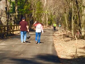
The warmth of this past weekend drew bikers, walkers, skateboarders and a slew of dogs to this new recreational path. In Stow, the path entrance is easily accessed from two points. Track Road, starting at Sudbury Road, runs along the Assabet River to White Pond Road. It is a hard-packed dirt and gravel roadway that brings trail users right to the Maynard line and the start of the trail at White Pond Road.
Users can also access the Trail from White Pond Road, directly off Rt. 117 just past the shopping center. A parking lot in the Assabet Wildlife Refuge at the end of White Pond Road is just beyond the trail entrance.
Over the past year, the Maynard section was laid out and graded along the old railroad bed, the same that had once run along Track Road. The trail currently has a base coat of hardtop and will receive the final topcoat later in the year. Landscaping and some final touches are still to come.
Maynard Rail Trail Committee member David Mark said the trail is sure to be enjoyed by many, both for its views as well as the gentle slope of the trail, which appears to be completely flat along its course. The first half-mile of trail from the Stow line meanders along the river through the woods, offering views of the river, small ponds and streams. A small park along the shore marks the site of a former ice house, with historical markers describing the local ice industry and other uses of the River in earlier times.
Views across the largest expanse of the River to the top of the Ben Smith Dam offer a perspective not seen while passing by on the roadway. Tributaries feeding the Mill ponds are evident as the path comes closer to Maynard’s downtown.
Right now, some small portions of the trail near the downtown area closed while final surface work is being done. Clearly marked detours to the parallel adjacent street make for a smooth transition from the path and then back to the next open portion.
The area along Maynard’s Main Street near the Mill is well marked for bicycle crossings with signage directing users to the next spot where the trail continues. A large bridge was hoisted over the Assabet, replacing an earlier one from the 1980s, to carry trail users safely to the parking lot behind CVS and continuing beyond the Outdoor Store, avoiding the traffic-heavy roadways through the downtown. The bridge is not yet open for use, with some finishing touches still to be put into place before it is deemed safe to open, according to Mark.
Continuing behind Nason Street and beyond, the trail again picks up the rail bed running behind homes and parallel to Rt. 27, where the trail is paved up to the Cumberland Farms store. Beyond that point, the trail is still being constructed.
As it crosses the town line into Acton, it will head in and out of woodlands eventually crossing Fort Brook Pond, where a new bridge is waiting to be put into place, and then continue to the parking area across from South Acton Train Station.
Mark is pleased with the use the trail is already getting, after many months waiting and watching the construction. Stow is now the only missing link in the chain of the trail, according to Mark, despite more than a decade of local committees trying to find a solution.
In Stow, the same rail bed that hosts the Maynard trail, runs along Track Road, beyond Sudbury Road and alongside the Honey Pot Hill Orchards property. The open access to the orchard property that a potential Trail may have offered along this bed was not looked upon favorably by the abutters, according to posted minutes of early Assabet River Rail Trail Committee meetings in Stow. The Stow Rail Trail committees were unsuccessful in obtaining the necessary easement to place the trail along that property.
While an easement was purchased for recreational public use along Track Road after a positive Town Meeting vote, turning that roadway into a Rail Trail proved more difficult than creating a trail along the similar roadway just across the line in Maynard.
In Stow, vehicle access on Track Road has to be maintained for those vehicles traveling to and from Crow Island, home to an ultralight flying club, as well as other activities. In order to accommodate vehicles and create a safe area for pedestrian and bike travel, the road would have to be widened and possibly divided, at great expense, according to reports submitted to the Town from the Assabet Rail Trail Committee design consultants.
David Mark is hopeful that a connection winding through the roadways of the Assabet Wildlife refuge may someday be a possibility, allowing the trail to link up to the Hudson leg. This option would offer a new route across Stow land and one that can ultimately offer complete linkage for the trail.